


Long-range weather forecast for UK reveals 2014 will be a SCORCHER!
BRITAIN is set to roast in a THREE-MONTH heatwave that could smash ALL summer weather records, forecasters claimed tonight.Published: Wed, April 9, 2014
http://www.express.co.uk/news/nature/469361/Long-range-summer-weather-forecast-for-UK-predicts-100-days-of-sun-and-record-temperatures
That was not the Met Office, wise. Couple of days ago (maybe 17th August) there was muttering about a ground frost in a few places if the wind falls light. Wind has been pulling in Artic air for some days now.
Night 17th/18th Exeter Airport dropped to 5.8C, far south west of England. Previous night Breamar Scotland 8.8C, traditionally the coldest place.
Central heating here wanted to trip on first thing in the morning over the past few days, mean temperature outside well below setpoint.
From Met Office Datapoint, I’m still working on these plots. Red is air temperature, pink is dewpoint. No other data from this station.
Three days, looks like the minima is humidity limited, to be expected when the ground is wet.


Still awake? Look at now in the above, at 23hrs UT it is already 5C colder than the night before so tonight is very likely to drop colder. Probably still too much humidity for a frost, there at least.

Non-standard met instruments at Chilbolton but not usually far out, dropped to 7.4C at dawn, too much humidity to drop far. Note how the wind is very calm overnight then picks up a few hours after dawn as the humidity tries to burn off. (is in knots) Maybe that ought to be SCORCH off, right, extra blanket on bed, I was wearing gloves last evening.
This is weather, swings one way they then other to make up for it.
Someone asked for a winter forecast. Go away. Actually I will say something: last year had no cold snap so if there is no cold snap before 1st January this year will be proclaimed as very hot, Nyquist will roll over. Normal is a cold snap so this winter is likely to have one. The timing scatters, usually after 1st Jan.
Autumn? Cold now so it will warm up to normal for the season. Wet or dry? No idea.
Post by Tim

Reblogged this on CraigM350.
Must be some very red faces (certainly not sunburn induced) over this :
http://www.express.co.uk/news/nature/493781/SHOCK-WEATHER-FORECAST-Hottest-August-in-300-YEARS-on-way-as-jet-stream-BOILS-Britain
Cool and cloudy where I am, so it looks like I will be denied seeing the very close Venus/Jupiter conjunction for the second night running.
Where are these “Mediterranean summers” we were promised?
Oh yes I forgot about that one AIP, might happen yet.
Lets have a look at some GCM.
Get a touch of more westerly later on, not quite as chilly but whoops, 24th (Sunday) if that comes to pass the west coast gets a heck of a blow, gales on exposed coasts, less so further east. Heavy rain across the country, frontal system into early hours Monday. Maybe, never sure that far out in time.
English summer normality. Gets wetter as the year progresses. Farmers are going to be displeased, want a warm dry spell and no wind to flatten corn. Not so bad with the short stalk varieties many plant these days.
Met Office headquarters are located at Exeter. 🙂
Frost please right there.
I must admit to being just as wrong as the Met Office. I was expecting a really hot summer in 2014 given my childhood memory of 1947 where the snow started in mid February and did not melt (in Pembrokeshire) until April.
I remember walking along roads that were marked by hedgetop twigs poking through seven feet of snow.
The following July and August were the hottest months that I ever experienced in the UK.
Here in North Carolina, where our summers are usually rather brutally hot and dry, we’re having the mildest (coolest, wettest) summer in memory. Last summer last year was unusually mild, too, but this summer is even milder, so far.
I live in Milford Haven, Pembrokeshire. All we had this last winter was rain — lots of it! Can give you the figures as recorded in my garden rain gauge. Been very mild. The window thermometer read 10C this morning but the harbour reports minimum of 11.3C http://www.milfordweather.org.uk/atmospheric.php
Please look at:
http://arctic.atmos.uiuc.edu/cryosphere/arctic.sea.ice.interactive.html
It is also worth attention to the warm currents of the Atlantic.
http://www.opc.ncep.noaa.gov/Loops/GRTOFS/currents/GRtofs_Curr_Atl_03_Day_flash.shtml
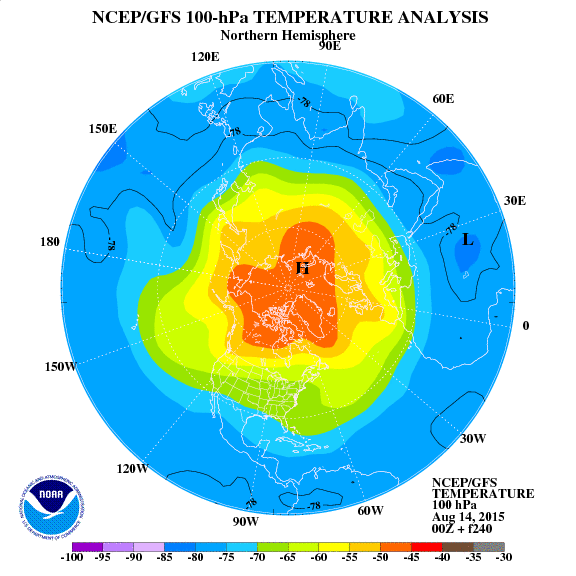
The cause is in the stratosphere, the ozone layer. Brown contour shows the circulation. Currently is as follows:
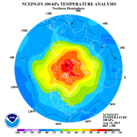
Forecast for 10 days is:
http://www.cpc.ncep.noaa.gov/products/stratosphere/strat_a_f/gif_files/gfs_t100_nh_f240.gi
We can already see explicit anomaly pressure above the Arctic Circle.
http://www.cpc.ncep.noaa.gov/products/intraseasonal/z200anim.shtml
Cosmic rays from 30 days is quite high. Average counts of Oulu exceeds 6200 The sun is a lot less active spots.
http://cosmicrays.oulu.fi/webform/query.cgi?startday=18&startmonth=07&startyear=2014&starttime=00%3A00&endday=18&endmonth=08&endyear=2014&endtime=00%3A00&resolution=Automatic+choice&picture=on
I love listening to the BBC Met Off forecasts. It’s fun watching how difficult it is for them to say “cold”. It’s always chilly or near average. Anything but cold.
The global temp anomalies tell the story..
Only shows the 1st -17th Aug. 2014 but it shows cold anomalies over the UK and Australia
https://picasaweb.google.com/110600540172511797362/TEMPERATURE2014#6049179675077466226
A weatherzone forum member had to mock the WZ news team to get them to post a cold news report.. and verily . Here is one
http://www.weatherzone.com.au/news/top-enders-dig-out-the-long-johns/123602
Stephen Richards
The MO weather forecasters on TV make me smile when they say rural areas will be several degrees/quite a bit/noticably cooler, even in winter it’s always cooler never colder as you say. What ever happened to the UHI of 0.1’C and how much is several?
Another bad year for Tomatoes, grrrrr.
What do the temperature at Exeter actually do last night?
Not as I expected, of course 🙂
Flat lined.
This also highlights a major topic I want to raise sometime but requires a lot of work doing first. Humidity is one of the most difficult to measure meteorological parameters.
Getting within 5% is not bad going…now consider what if thermometers were 5% out, equates to 15C, yes fifteen. (5% of 300K)
Water is the dominant weather parameter, climatic parameter and yet the measurement, the data is scattering all over the place.
Ahhh, I remember measuring humidity with a whirling psychrometer in a university car park in heavy November rain, in the dark. It came up with a figure of 100%, which I found credible. 🙂
Ben Vorlich,
You want the cold facts?
I can only tell as I understand the situation.
UHI in most cases is small but hard data is missing.
I can point at generally competent sites on cool but also at severe cockups. This is sufficient to mess up the isotherm maps of the UK. (not named stations, bit short of time)
In the more common situation the meteorological stations are of low competence as much from human lack of care, mismanagement. Detail is what matters but that detail stretches physically as far as you ought to be able to see. Maintaining constant environmental conditions over many years doesn’t happen.
Is it reasonable if a site is in a frost hollow?
Or if in a small woodland clearing?
And so on.
An UHI effect I personally am promoting, not sure you will find anyone else doing this is the thermal coupling with mass, humans do this. See the Lunar modelling work done on the Talkshop but extends to general.
A clue that this is going on is diurnal temperature phase shift but data with sufficient resolution is hard to find. (part of why I am putting effort into capturing the Met Office hourly data, is no public archive)
Surprise surprise, this kind of UHI looks the same as the supposed CO2 effect.
The Met Office for example love their paving slab paths and duct covers in met enclosures. Same that they love fences. Okay fine but don’t know violate basics by trying to extract tiny temperature changes via averaging and claim it is actual.
The sad part is that a particular summer, hot, warm or cool, has nothign to do with climate. Only in this age of climate obsession is the idea that
1) a seasonal forecast is scientifically interesting
2)an indicator of climate
given any credibility at all.
@Tim Channon, trying to make sense of ground level temperatures is futile. Heat plumes over cities means descending cold air in rural areas, so one confounds the other. The only valid temperature measurements are at 5 km altitude which is the mid-latitude equivalent emissions height and the “tlt” satellite temperature. This is above the convective region (except for thunderstorms) so diurnal temperature variations are absent, but still one will see effects from CO2 which are masked at the surface by decreased lapse rate from higher moisture content. Break the surface thermometer habit. Of course, daily and seasonal temperature variations do have entertainment value.
Us see forecast pressure on August 29 in the lower stratosphere. It indicates direction of air flow.
http://earth.nullschool.net/#2014/08/24/0600Z/wind/isobaric/70hPa/orthographic=27.46,76.29,482
Promises to be interesting this year ice growth in the Arctic. Ice concentration is higher than 2012 and 2013. Can already see that the ice growth will be quick, particularly in the north of Canada.

Increase in ice in Antarctica will be a record.
http://arctic.atmos.uiuc.edu/cryosphere/antarctic.sea.ice.interactive.html
pochas, The article is about weather.
I agree with you for earth temperature, given choice I would use the subsurface temperature, the only measure of the body thermal energy level. This won’t work for ocean.
Literal surface and above surface is measuring an interfacial zone, within the energy transfer region.
UHI is a factor of interest to many and for me technically interesting.
Warwick Hughes has some fun from Australia
Renmark Aero has coldest ever 7 day run of August minimum temperatures – that is in eastern South Australia
and
Canberra Airport has coldest ever 14 day run of August minimum temperatures
Low last night was in Tyndrum, Scotland, 3.6C, I assume at station #3
http://www.bing.com/maps/?v=2&cp=td2vkdgmbdqt&lvl=18&sty=b&eo=0&q=56.419%20-4.66101&form=LMLTCC
Us see the temperature at an altitude of about 3500 m above Australia and moving polar vortex at an altitude of about 30 km.
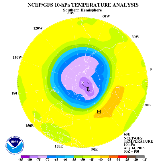
http://earth.nullschool.net/#current/wind/isobaric/700hPa/overlay=temp/orthographic=134.54,-39.18,481
The loss of ice in the Arctic clearly inhibited. The temperature of ozone in the stratosphere above the Arctic Circle is below average.
http://arctic.atmos.uiuc.edu/cryosphere/arctic.sea.ice.interactive.html
Forecast jet stream for 4 days is not beneficial for Europe. It will be cold and windy.
http://earth.nullschool.net/#2014/08/24/0600Z/wind/isobaric/250hPa/orthographic=16.60,56.25,636
Cool will also be in the central part of North America.
http://earth.nullschool.net/#2014/08/24/0600Z/wind/isobaric/250hPa/orthographic=-105.00,41.72,636
Can see that in the days that followed the North Atlantic will be strongly cooled.
http://earth.nullschool.net/#2014/08/24/0600Z/wind/isobaric/700hPa/overlay=temp/orthographic=80.86,88.18,482
pochas says: August 19, 2014 at 4:12 pm “The only valid temperature measurements are at 5 km altitude which is the mid-latitude equivalent emissions height and the “tlt” satellite temperature.”
Sorry, WE do not live at 5km in free air, we live on the Surface, so for Temperature data to reflect what human beings actually experience you have to use the Ground based thermometers.
That is one of the reasons that Satellite data does not tally with what we experience, especially on the ground.
The other problem with 5km readings is that you are measuring the heat “escaping” from the surface, especially at night so basically you are measuring cooling.
Lamb in a collection of essays published 1972 has a chart from Chandler 1962 which measured temps on 3/4 Jun 1959 for London.
Max 72 -78F
Min 51-60F
Largest range in the outskirts of the city.
The ‘hotspot’ is on the north bank of Thames by Poplar / Stratford which is the limit of the built up areas according to the map.
Prevailing 500mb flow at time was westerly according to MetO with warm & sunny 2-3rd with block by cold low going from Baltics to Balkans on 4-5th.
Let us see “global warming” in the Atlantic.
http://earth.nullschool.net/#current/wind/surface/level/overlay=misery_index/orthographic=-26.95,11.48,343
Looks like Exeter went down to 3.9C dawn 20th
Katesbridge, Northern Ireland, a cold site, edge of marsh, maybe frost hollow, 2.1C but these published extremes include noise. Same hourly data for Katesbridge says 3.1C
24 hours ending 2200 on 20 Aug 2014:
UKHighest max 0900-2100 20.4 °C Hurn
Lowest max 0900-2100 10.5 °C Cluanie Inn
Lowest min 2100-0900 2.1 °C Katesbridge
Highest rainfall 2100-2100 11.0 mm Kinlochewe
Sunniest 2100-2100 11.9 hours Yeovilton
Last updated: 0003 on Thu 21 Aug 2014
Here in Highlands (about 50 miles north-east of Tyndrum), we have been lighting the woodstove every night for the last week or so. Otherwise the house is just too damned cold. July was a great month, blue skies and warm sunshine for weeks, even the big lochs warmed up. However it has not been warm since early August, and we even had a frost (on a tiled summer house roof) on the morning of August 5th, when air temperatures can’t have been much above freezing.
I gather the Highlands are either wet or warm or windy or snowy or biting things… 8-|
Ground frost in August though at presumably a sensible altitude for living sounds unusual.
TC – It wasn’t a proper ground frost, only on a roof, but it was still white with ice crystals at 6 in the morning and the sun had been up for a while by then. This was at only 80m above sea level. Frosts in the Highlands are not unusual in late August – I think there was a -1C recorded on August 31st a few years ago at Altnaharra (or it could have been Tulloch Bridge)?
Oops, a surprise. Upper Lambourn 2.1C is close to here.
Earlier this evening I looked at the radio linked thermometers in the kitchen, record min and max, three are outside. Mostly I don’t bother looking, just note the immediate but when I looked the most exposed had a min at 2.0C but I don’t know when I last reset it, most likely a month or so ago.
It’s shielded but far from a cold place in the garden. Puzzled.
On seeing the following, huh? I know where that one is and ought to read much colder than here.
24 hours ending 2200 on 21 Aug 2014:
UKHighest max 0900-2100 19.8 °C Cavendish
Lowest max 0900-2100 11.9 °C Blencathra
Lowest min 2100-0900 2.1 °C Upper Lambourn
Highest rainfall 2100-2100 28.8 mm Achnagart
Sunniest 2100-2100 10.0 hours Lerwick
Last updated: 0003 on Fri 22 Aug 2014
Benson, the coldest synoptic station in the south of England, over a down from here dropped to 3.3C on near calm. Middle Wallop, UHI, dipped under odd looking conditions, wind shift, 4.8C
Boscombe, less clear, 5.4C
Chilboton, don’t have numbers yet, about 3C and I suspect a ground frost, are discontinuities. (this might be interesting when the full CNR4 data becomes available, weeks probably, what does a ground frost look like?)
1.8C
Weather should change over the weekend.
24 hours ending 2200 on 22 Aug 2014:
UKHighest max 0900-2100 21.2 °C Thorney Island
Lowest max 0900-2100 12.5 °C Cluanie Inn
Lowest min 2100-0900 1.8 °C Tyndrum
Highest rainfall 2100-2100 12.0 mm Resallach
Sunniest 2100-2100 11.7 hours Morecambe
Last updated: 0002 on Sat 23 Aug 2014
Tonight forecast to be “unseasonably cold” across much of the country.
Headline:
Showers easing away leading to an unseasonably cold night.
This Evening and Tonight:
Showers in the north and east will fade away and become confined to windward coasts this evening. Temperatures will fall sharply under clearing skies and light winds with a grass frost likely by dawn in some rural locations.
http://www.metoffice.gov.uk/weather/uk/uk_forecast_weather.html
So now they mention it’s below normal. Been hammering away at above normal when it is warm. Weather. 🙂
I read it brief clear spell with calm before a low pressure system moves in with wind and rain Sunday night through Monday. This is as I mentioned on the 19th except is not as severe as early forecast guessed.
What is the strangeness called “grass” frost? Always was ground frost.
0.4C at Katesbridge.
Tonight the Met Office says cold but here it was warmer at 23hrs than a few nights ago.
24 hours ending 2200 on 23 Aug 2014:
UKHighest max 0900-2100 20.5 °C Thorney Island
Lowest max 0900-2100 11.4 °C Loch Glascarnoch
Lowest min 2100-0900 0.4 °C Katesbridge
Highest rainfall 2100-2100 11.8 mm Albemarle
Sunniest 2100-2100 11.5 hours Morecambe
Last updated: 0002 on Sun 24 Aug 2014
Benson ought to be cold with no wind and clear. If it stays like that it all depends on water, whether mist forms and how much water drops out. At that rate of drop, down to 2 or 3 by dawn but linear doesn’t happen.
2300 7.1 °C WNW 1 mph 24 km 1018 hPa,
0000 6.5 °C SSW 1 mph 25 km 1019 hPa,