


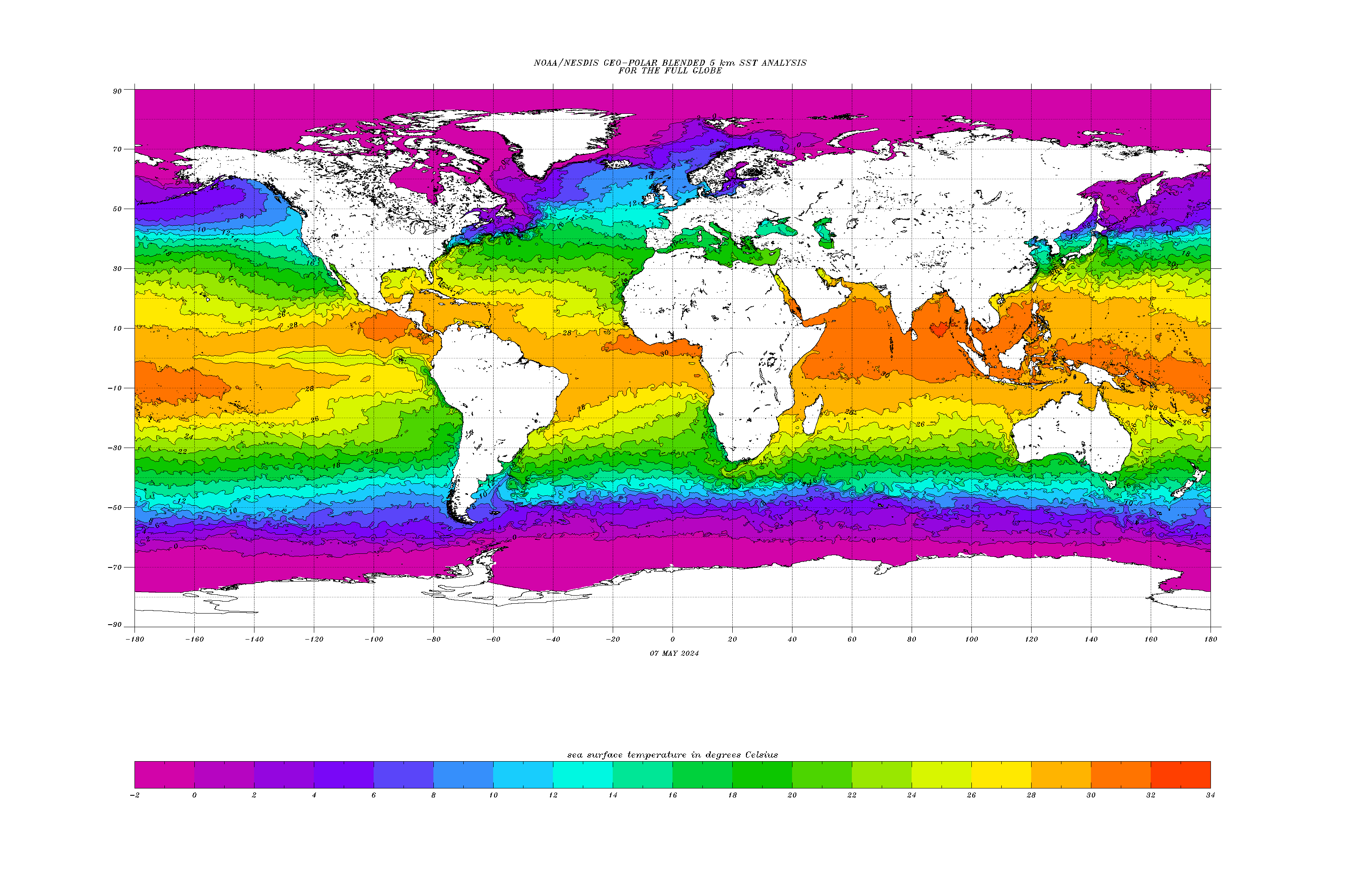
![Maps of sea surface temperature anomaly [credit: NOAA]](https://tallbloke.files.wordpress.com/2015/04/enso9798.jpg)
Maps of sea surface temperature anomaly [credit: NOAA]
What follows are extracts from the US NOAA’s own blog. They report: ‘After twelve months of El Niño Watches, we are issuing an El Niño Advisory.’ But the conditions are ‘extremely weak’ at this time [note: the maps shown are NOT current conditions]:
Over the last several months, we’ve seen warmer-than-average sea surface temperatures (SSTs) in the tropical Pacific, including the Niño3.4 region, which we track as one indicator of El Niño. The seasonal Niño3.4 Index has been at or above 0.5°C since September, and the most recent weekly Niño3.4 index was +0.6°C.
The El Niño/Southern Oscillation (ENSO) is a coupled phenomenon, though, so we also monitor the atmosphere for signs that it is responding to those positive SST anomalies. For the last few months, we’ve been seeing some suggestions of borderline atmospheric El Niño conditions, but until this month [March] we were below that borderline. This month, we’ve finally crept above it, and thus NOAA is declaring the onset of El Niño conditions.
But what does it mean for North American and global weather?
At this time, these are extremely weak El Niño conditions, during a time of year when the influence of El Niño on weather patterns in North America or other locations outside of the Tropics is weakening. For example, historical precipitation patterns associated with El Niño show that only about 3 of the past 10 El Niño years exhibited above-average rainfall in California during March-April-May (map pair below). Another way of looking at the historical relationships shows that ENSO has very little correlation to precipitation over North America during the spring.
The current warm SST anomalies are greatest in the Central Pacific (see map below). ENSO events centered in this area tend to be weaker (see Michelle’s post on ENSO flavors for more on this).
Especially since the rainy season in the West is winding down by March, it is unlikely that these current El Niño conditions will lead to substantial, drought-breaking rains.
What’s to come?
The CPC/IRI consensus forecast calls for an approximately 50-60% chance that El Niño conditions will continue through the spring. In the ocean-atmosphere coupling indicative of El Niño, warmer waters lead to atmospheric changes, and those atmospheric changes in turn help maintain the warmer water. So, it’s possible that even the weak coupling we’re seeing now will support the continuation of the positive SST anomalies. As I mentioned above, the recent westerly wind anomalies and the downwelling Kelvin wave will also help to keep the SSTs above average for the next few months.
Dynamical climate models are mostly forecasting a slow increase in the Niño3.4-region SST anomalies throughout 2015. Springtime is a difficult time of year for forecasting, as models traditionally have some difficulty seeing beyond the so-called “spring barrier,” and so the CPC/IRI consensus forecast probabilities decrease somewhat going into the summer, as forecast confidence decreases. That said, probabilities remain at or above 50% that El Niño conditions will continue through the fall.
After twelve months of El Niño Watches, we are issuing an El Niño Advisory. However, what it really represents is an incremental crossing of the borderline. If we follow the “Is it El Niño Conditions” flowchart, the warmer SST conditions, our anticipation that they will continue for the next several seasons, and signs of weak atmospheric coupling over the past month, mean we arrive at “yes!” From an impacts perspective, this is not particularly momentous, as El Niño impacts are weak in the spring and summer. Still, after months of hovering under the threshold, we can now say that El Nino conditions have arrived.
Source: March 2015 ENSO discussion: El Niño is here | NOAA Climate.gov.
NOAA’s Climate Prediction Center synopsis says:
‘There is an approximately 50-60% chance that El Niño conditions will continue through Northern Hemisphere summer 2015.’
Nothing so far to suggest any unusual temperature movements might be on the way.
***

Maybe there’s more caution this year after last year’s talk of a big El Nino that never happened e.g. this one from NASA: ‘El Niño: Is 2014 the new 1997?’
http://science.nasa.gov/science-news/science-at-nasa/2014/19may_elnino/
We’ve had weak El Nino conditions for the last 12 months.
http://www.esrl.noaa.gov/psd/enso/mei/
” probabilities remain at or above 50% that El Niño conditions will continue through the fall.”
Heads or tails mate? 🙂
Still, it’s in line with our celestially based prediction that lunar cycle alignment plus a falloff in solar activity would coincide with an El-Nino this year.
It’s about 18.6 years since the last ‘super El Nino’ of 1997-8.
‘Our study explores the hypothesis that some temperature anomalies in the north-eastern Pacific, even some of those currently attributed to ENSO, were influenced by the 18.6 year lunar nodal cycle (LNC).’
http://onlinelibrary.wiley.com/doi/10.1029/2006JC003671/full
‘We also note that the response of North American coastal SSTs to many major El Niños of the 20th century are confounded with the SST response anticipated by the LNC. This unlikely coincidence will attract greater attention if a major El Niño occurs around 2015.’ [SST = sea surface temperature]
I think SSTs are a reasonable proxy for natural variability over the last century or so. The long-term trend is 0.5C/century with multi-decadal periods as high as +1.7C/century, and as low as -0.3C/century. The latter one was enough to cause an ice age scare.
In advance of COP Paris, some want to project warming of +1.5C as requiring action. We’ve been there twice already recently, and much warmer still in the distant past.
Conclusion:
Living on our water world means our temperatures and precipitation fluctuate according to ocean circulations and oscillations, especially ENSO and IPO patterns in the Pacific basin.
https://rclutz.wordpress.com/2015/04/05/climate-report-from-the-water-world/
‘There is an approximately 50-60% chance that El Niño conditions will continue through Northern Hemisphere summer 2015.’ -NOAA
Interesting how it’s basically down to a coin flip whether an El Niño will occur this year given current data, yet they are so damned sure about what the climate is going to be like in the year 2100 if we continue to use fossil fuels.
Colossal fools.
The wishful thinking of the ultra-warmist Guardian newspaper and its pro-IPCC sources last year is good for a laugh.
From their June 2014 report entitled ‘How El Niño will [sic] change the world’s weather in 2014′:
‘The global El Niño weather phenomenon, whose impacts cause global famines, floods – and even wars – now has a 90% chance of striking this year, according to the latest forecast released to the Guardian.’ – Wrong.
‘India is expected to be the first to suffer, with weaker monsoon rains undermining the nation’s fragile food supply, followed by further scorching droughts in Australia and collapsing fisheries off South America.’ – Wrong.
‘But some regions could benefit, in particular the US, where El Niño is seen as the “great wet hope” whose rains could break the searing drought in the west.’ – Wrong again.
http://www.theguardian.com/environment/2014/jun/11/-sp-el-nino-weather-2014
When ‘90% chance’ forecasts don’t work out, why should anyone believe any so-called ‘climate science’ claims?
Still waiting for those ‘global famines, floods – and even wars.’ LOL
oldbrew,
The climate kooks will have to improve the memory hole further. They already, of course, control the editorial content of nearly every paper but those historical archives are a definite hole in the dike.
The Guardian seems to have no critical faculties at all when it comes to anything related to climate science.
They happily swallow and regurgitate any ‘alarmist’ forecast or study as though it must be the infallible truth.
Then move swiftly on when it turns out not to be so 😉
More of the same Guardian hype here (from 2013, h/t Steven Goddard):
‘White House warned on imminent Arctic ice death spiral’
http://stevengoddard.wordpress.com/2015/04/06/us-government-warns-that-the-arctic-will-be-ice-free-in-three-weeks/
Oldbrew, thanks for the reminder re The Guardian cobblers. How anyone takes that rag seriously is beyond me (actually that goes for most of the MSM). Still we can look forward to the article “adjustments” a la Orwell in the not too distant future.
This current weak El NINO should dissipate by the late fall, by winter for sure. The structure of sea surface temperature anomalies in the Pacific do NOT encourage a protracted or strong El NINO going forward.
The waters around Australia are to warm and the waters off the lower South America West Coast are to cold.
In addition angular momentum charts are in negative territory which is not indicative of El Nino conditions.
The controversial BBC took the trouble to make one bankable prediction and contrive a link to global warming theory: They postulated that England would do badly at the World Cup in Brazil (guaranteed) because of an El Nino. Obvious, really.
“Scorching El Nino event could scupper England’s World Cup”
http://www.bbc.co.uk/news/science-environment-27343057
Guardian: ‘The effect of climate change on the cycle is not yet understood, though some scientists think El Niño will become more common.’
Can’t see it here…

[click to enlarge]
Taking the linked mei enso data and doing something trivial
[mod: err, umm, what?
TwoSEVEN uploads, changed files, wordpress refuses to display a png, tearing hair out, Automattic have right royally screwed up, again. PNG is now screwed, unless you care not about other people, I do try and care. a 50kB file becoming 250kB is a joke, JPG is not suitable. Okay, larger but they haven’t yet screwed GIF. Not the only problem either. –Tim]A curiosity.
I’ve long wondered about the data validity, with plenty of words out there asking the same question.
You can see that in the 70s AMO index was the lowest value. We remember that the solar cycle was weaker. Now AMO will also decrease faster. I greet Vukcevic.
http://www.vukcevic.talktalk.net/SUN-and-AMO.htm
Ren ,you are making a case that the AMO and solar cycle are in correlation. This will be interesting. If correct the AMO should be going into a negative phase as solar cycle 24 declines.
Warm (>+0.5oC; red stippled line) and cold (<0.5oC; blue stippled line) episodes for the Oceanic Niño Index (ONI), defined as 3 month running mean of ERSST.v3b SST anomalies in the Niño 3.4 region (5oN-5oS, 120o-170oW)]. Base period: 1971-2000. For historical purposes cold and warm episodes are defined when the threshold is met for a minimum of 5 consecutive over-lapping seasons. The thin line indicates 3 month average values, and the thick line is the simple running 7 year average of these. Last 3 month running mean shown: December 2014 – February 2015. Last diagram update 6 March 2015.

I didn’t say the simple thing I did.
Cleanly low pass filter the data then differentiate. All done with zero time shift.
Plot
tchannon says: April 7, 2015 at 11:58 pm
“Plot”
‘Plot’??? It would seem Word press is being unkind to you Tim!
I’ve often considered that SST may be governed by ‘SS’ (Sea Surface) ‘substrate’ energy levels. This involves a ‘time shift’ (lag). Let me explain my consideration. 🙂
Surface temperature can only affect the temperature of the ocean/sea ‘surface’. By virtue of its ‘IR’ (infrared) radiative property, and surface mixing by ‘wavelet kinetic’ (which also covers the ‘conductive contact’ scenario). The problem is that ‘surface conditions’ don’t alter enough to generate an El Nino/Le Nina event (even when changing ocean/sea currents are taken into consideration).
However, a ‘changing’ energy input into regions ‘below’ ocean/sea surface would affect SST by altering the ‘substrate’ (lower ocean/sea depths) that the surface interface reacts with.
My prime candidate for this mediator of/to ‘lower depths’ is ‘insolation’ within the region of ‘blue vis’ and ‘UVa/UVb’. These wavelengths of insolation enjoy the greatest ‘depths of penetration to extinction’ for any spectra of insolation into water and a typical UV species penetration is also seasonally dependant on ozone propensity.
Best regards, Ray.
I’m not happy about the lack of a solid explanation for things such as the 1998 event. This requires evidence.
Sea surface doesn’t mean surface, rather it is some varying water temperature location. It ought to be say 1.5 metres above the surface, same as land. The two are not equivalent, surprisingly with no attempt at making land measurements equivalent.
Water layering is normal, breakouts from a layer will be normal. These are not recorded, as usual Argo is woefully defective, the usual science nonsense.
Question: what were the radiosonde results where they were put up from ships in the middle of the 1998 event? Were there detailed radiative measurements done at sea?
El Nino warmth is evaporating – after it’s gone, with a weak Sun, temps will drop. HadSST global monthly temps have fallen every month since last August
Tchannon is the most important the circulation (wind) and the cold Humboldt current (cold southern ocean).

Bob Weber


SST
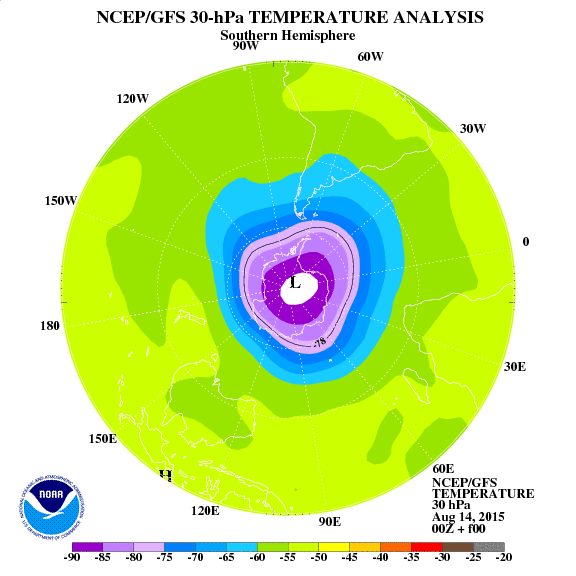
See the current circulation in the lower stratosphere.

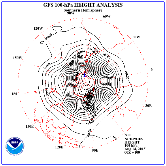
Click image (SH).
Blocking already can see (in the area southern magnetic pole).

Radiation GCR increased.
‘How The 1998 El Nino Went Over To The Dark Side’
http://stevengoddard.wordpress.com/2015/04/07/1998-el-nino-went-over-to-the-dark-side/
Suricat promises to be a the chilly winter in Australia.
At a higher altitude even more you will see that is repeated in the south polar vortex pattern of the previous year. Will be inhibited south of Australia.
Unseasonably wintry weather hits parts of Japan
NHK — APR 08
Many areas of eastern and northern Japan are seeing unseasonably wintry weather on Wednesday.
The Meteorological Agency says the chilly weather is being caused by a cold air mass. It says temperatures are expected to remain low throughout the day.
Snow and sleet fell in many areas in the morning in the Kanto Region, even in low-lying areas.
Weather officials say 2 centimeters of snow fell in Utsunomiya, north of Tokyo.
Snow was also recorded in central Tokyo. This is the first time in 5 years that Tokyo has seen snow in April.
– See more at: http://newsonjapan.com/html/newsdesk/article/112074.php#sthash.j2SNltqA.dpuf
I concur.
“Sea surface doesn’t mean surface, rather it is some varying water temperature location.”
Yes, AFAIK the ‘temp’ relates to ‘water’ at an approximate ‘near surface’ (1-2 metres) depth for any measurement other than satellite.
“It ought to be say 1.5 metres above the surface, same as land.”
If that were so, it would be a ‘near surface air temp’ and not ‘SST’.
“The two are not equivalent, surprisingly with no attempt at making land measurements equivalent.”
I concur. It would be nice to know ‘near surface soil temp’ as well.
“Water layering is normal, breakouts from a layer will be normal.”
Yes, and “breakouts” ‘usually/often’ mediated by ‘tidal’ influence.
“These are not recorded, as usual Argo is woefully defective, the usual science nonsense.”
No surprise here Tim. Earth has a ‘lot’ of water. I share your frustration.
“Question: what were the radiosonde results where they were put up from ships in the middle of the 1998 event? Were there detailed radiative measurements done at sea?”
Sorry Tim. Without researching this (again), I don’t have a clue (lost data). 😦
Best regards, Ray.
tchannon says: April 8, 2015 at 3:20 am
This was missing from my last post!
Best regards, Ray.
tchannon says: April 8, 2015 at 3:20 am
“Question: what were the radiosonde results where they were put up from ships in the middle of the 1998 event? Were there detailed radiative measurements done at sea?”
With some free time a short search came up with this:
http://data.eol.ucar.edu/codiac/ds_proj?ITOP
You’ll need to look for the year, and ‘please ignore’ any data that mentions ‘satellite’, or ‘forecast’. However, I think ‘dropsonde’ data is equipotential with ‘radiosonde’ data, it’s just collected in a ‘downwards’ direction instead of ‘upwards’. 🙂
If I find something more relevant I’ll post it here later.
Best regards, Ray.
Looks like those are from 2010. Conceptually they fly upside down, saves confusion.
I’d vaguely heard of those, not come across them as such.
Thinking about this there will be differences.
There are no ground based site readings. A balloon tends to ignore the near surface, very poor data (rise too fast), but will float longer for upper air.
Possibly most critically the instrument conditions are different, a balloon is close to static, buoyant with the air whereas a drop, presumably parachute, has an airspeed. Equating the two sets of conditions when even for balloon sonde there have been instrument troubles, will affect different instruments err, differently.
Anything else?
Boils down to all we have.
tchannon says: April 11, 2015 at 8:46 am
“Boils down to all we have.”
Perhaps not. Here’s something I found about the ‘NOAA Ship RONALD H. BROWN’:
http://www.moc.noaa.gov/rb/science/equipment.html#metsens
To quote here; “WOCE Meteorological Sensors
A set of Woods Hole manufactured IMET sensors are installed. The sensors include wind speed/direction, temperature/humidity, rain gauge, short-wave and long-wave radiation, and sea-surface temperature. These sensors are calibrated annually. Their calibration values are incorporated on their onboard ROMs and the data that they output is in calibrated values. The data from the IMET sensors are recorded on SCS and are available for scientific use.” and I note, “…, temperature/humidity, …” ‘sensors’ are included.
Thus, the “data from the IMET sensors are recorded on SCS and are available for scientific use” needs more research.
If you find the data, let me know. If I find the data, I’ll let you know. 🙂
Best regards, Ray.
Well, I got as far as ‘this’ when the NOAA page went dead:
http://catalog.data.gov/dataset/climate-data-online-cdo/resource/c62aef4a-a09d-4b54-9251-5adcf6838db9
Too late to continue, I’ll try to get back to this later.
Best regards, Ray.
[mod note] site message: ‘Attention: NCEI HDSS Access System (HAS) is currently unavailable. Access to the affected systems should be restored by Monday, April 20. We apologize for the inconvenience’
Hi again tchannon.
A search for ‘ship-logged data’ during/spanning the 1998 El Nino period came up with nothing, but a search for ‘IMET temperature data’ resulted in this statement:
“Web Page
Resource Quality
Rating: *****
About these ratings…
URL: http://www.ncdc.noaa.gov/cdo-web/search
From the dataset abstract
Climate Data online or CDO provides access to climate data products through a simple, searchable online web mapping service. Users can find a variety of NCDC products via CDO including…
Source: Climate Data Online (CDO)
Info icon
This content cannot be displayed in a frame
To help protect the security of information you enter into this website, the publisher of this content does not allow it to be displayed in a frame.
What you can try:
Open this content in a new window”
NB. The “Info icon” was a large white ‘cross’ (‘X’) on a red, circular, background. A typical ‘Windoze’ proscription icon! Also, the “Open this content in a new window” phrase was an active link.
———————————-
I followed the link to a ‘new window’ and got this:
“[PDF] C WRF-NMM & GSI Analysis To Replace Eta Model & 3DVar in …
nomads.ncdc.noaa.gov/docs/WRF-NMM-replacing-Eta-in-NAM.pdf
Eta-3DVar vs WRF-GSI Data type Eta 3DVAR WRF GSI Overland sfc temperature obs Yes (through 2DVAR only) No GOES layer PW Yes No … – In Fire Weather / … ”
This seems to refer to a ‘model’ comparison, of sorts, so I downloaded the pdf from here (BEWARE 8.38 MB download):
Click to access WRF-NMM-replacing-Eta-in-NAM.pdf
A search for ‘observed surface data’ seems impossible at this site. I give up! 😦
Best regards, Ray.