


The Massive NH Winters Set to Continue.
Posted Tue, 07/30/2013 – 20:15 by Geoff Sharp
The previous massive winter forecasts can be found at:
http://www.landscheidt.info/?q=node/224
http://www.landscheidt.info/?q=node/189
http://www.landscheidt.info/?q=node/270

The Worlds oceans as of July 2013 above.
During what will be known as the Landscheidt Minimum we have so far experienced massive winter events especially in the Northern Hemisphere over the past 3 years. This coming winter event will be no different as the solar conditions continue to look weak during the very low cycle max of solar cycle 24, and the cool PDO conditions also look to prevail.
The jet stream has been a major driver in both hemispheres for cooler winters, along with the blocking highs and more prevalent and intense low pressure systems that are inter related. The current winter in Australia has seen weekly low pressure systems dominate our weather patterns that have not been predicted by our BOM. They are not aware of the solar influence to our atmosphere it would seem.
The current EUV levels are still very low and are not expected to increase according to my prediction for at least 25 years, so we had better get used to the jet stream conditions and abundance of low pressure systems world wide. Along with this the cool phase of the PDO which normally lasts 30 years is just beginning and should encourage La Nina conditions over El Nino. The last 3 years have been 2 La Nina and 1 neutral (La Nina bias) and this next winter looks very likely to be in another La Nina condition. The current state of the northern Pacific is La Nina friendly with a warm pool off the Japanese coast set to move south which will increase the current warm pool above New Guinea. This will drive the Walker pump if conditions continue and the cool water is already amassing off the Peru coast.
The position of the NH jet stream has been influenced by the AO or NAO over the past 3-4 NH winters. Last year the neg AO directed the jet stream to be most destructive over western Europe and the USA. This year could be different in respect to where the most severe impacts will be felt. The QBO which looks to be involved with the northern polar vortex breakups is moving towards its westerly phase, this phase is not as conducive to negative AO formations, as the planetary winds are not encouraged as much to travel north to impact the polar vortex and the associated impacts on the AO. If this trend continues we would be less likely to see as much negative AO activity as last year which will shift the jet stream position to impact Eastern Europe and China.

Expectations for future NH winters should remain the same during this cycle max, but if the solar conditions deteriorate from their current low position and begin to degrade into a downward spiral towards an early cycle minimum we may see even worse conditions develop as the EUV values slump. Only a sudden sustained increase in solar output will improve conditions, that is now considered very unlikely.
Welcome to the Landscheidt Minimum, solar and climate science is set to learn a lot during this most interesting era.


Aren’t “interesting times” fun?
I agree the tendency is for harsher winters. but I also suspect there’s more to winter weather and the jet stream than solar activity. A mild winter certainly cannot be ruled out.
Good call Geoff.
Pierre, ENSO is a major factor, and pinning down the relationship between solar and ENSO is the tricky part. I have a general idea of what happens, but seasonal forecasting is hard, because the triggers for specific ENSO events are hidden in the clouds. We’re getting closer though, and a firm understanding of QBO as Geoff is working towards may be one useful route to knowledge IMO.
There are roughly speaking, three el ninos per solar cycle. the big one occurs soon after solar minimum when the ocean goes into reverse and kicks heat out instead of absorbing it, unless there was a volcanic eruption in the previous cycle, in which case the PWP is already partially discharged. Consequently the following big la nina usually occurs near solar max. That’s why there’s often a dip in global T near solar max.
If you smooth the temperature data at 1/3 solar cycle or at the average frequency of the ENSO cycle (around 40 months) you get a good correlation between solar activity and global temperature. The amplitude isn’t that big, but this is due to the antiphase nature of ENSO surface temps and solar cycle described above. The Sun is having a large effect, but it’s hidden below the surface, most obviously in the Pacific Warm Pool.
http://woodfortrees.org/plot/hadsst3sh/from:1955/mean:37/detrend:0.6/plot/sidc-ssn/from:1955/scale:0.001/offset:-0.3/mean:12
We do not forget the dynamics of stratospheric.
Stratospheric Warming events and Solar Cycles
Rog, could you please fix my typo, it should read Japanese “coast”
[Reply] Fixed.
Len Holliday of Firsthand Weather writes:
“Ulric Lyons, is a great friend of mine. And perhaps one of the best long-range forecasters in the world today! He has forecast a UK Winter of severe cold and snow for the Winter of 2013-2014 with even worse conditions for U.S. east of the MS. with the N.E. U.S. getting slamed with Arctic Cold and have violent Snow-Storm events!”
Hi Len. As you know, I am forecasting a long intense cold shot starting from around the 7th January 2014. The first signs of any warmer bursts are in the last 10 days of February, which for the UK/Euro will likely result in heavy snow falls, and the Atlantic flow finally breaking through early March. The (north east?) U.S. could see the cold continue further into March.
This is a solar based forecast, produced entirely from heliocentric planetary angular analysis.
http://www.linkedin.com/groups/Winter-2013-2014-is-coming-4786004.S.259614043
@Rog, ENSO doesn’t matter much here, if anything it will respond to the cold shots by turning towards Nino conditions, as it did from Dec 2010, Feb 2012 and March 2013:
http://www.bom.gov.au/climate/enso/indices.shtml
Unless there is major ‘shakeout’ to the north of Iceland, the N. Atlantic surface temperature is set to plunge
http://www.vukcevic.talktalk.net/SST-NAP.htm
even if there is it will take some years to recover.
I tend to agree with Ulric about the Enso being only a minor player in the N. Atlantic.
TB, I’m totally baffled by this. My bold.
“There are roughly speaking, three el ninos per solar cycle. the big one occurs soon after solar minimum when the ocean goes into reverse and kicks heat out instead of absorbing it,”
I think I have a fair idea of the changing temperature gradient in the ocean column as heat is absorbed. I completely fail to understand how heat from lower temperature raises surface temperature. In the polar regions, maybe, but along the equator? I’ve always assumed the warm surface pool is moved east or west by prevailing winds. This created the El Nino La Nina conditions. Seems like I have it all wrong as usual. Any chance of a link to a layman tutorial?
Geoff said:
“The QBO […] is moving towards its westerly phase, this phase is not as conducive to negative AO formations,”
Rubbish, it gets completely overwhelmed by the short term solar signal, as in Dec 2010. There’s plenty of strong -NAO periods during westerly QBO:
http://www.esrl.noaa.gov/psd/data/correlation/qbo.data
http://www.cpc.ncep.noaa.gov/products/precip/CWlink/pna/norm.nao.monthly.b5001.current.ascii.table
“The position of the NH jet stream has been influenced by the AO or NAO over the past 3-4 NH winters.”
It’s done it all year round for millions of years!
Richard, think in terms of energy rather than temperature, my sloppy wording.
Ulric Lyons says:
August 3, 2013 at 11:56 am
Geoff said:
“The QBO […] is moving towards its westerly phase, this phase is not as conducive to negative AO formations,”
———————————–
Rubbish, it gets completely overwhelmed by the short term solar signal, as in Dec 2010. There’s plenty of strong -NAO periods during westerly QBO:
Ulric up to his normal form I see.
The QBO was in its westerly phase the winter of 2011/12, which saw a mainly positive AO. The positive AO positioned the jet stream away from the UK for most of the winter. I just go on the facts and am not interested in the position of Ceres for forecasting reasons.
Can I suggest you educate yourself, by reading Baldwin et al who are the acknowledged experts in this field.
Click to access qbo_baldwin.pdf
I am not sure what AO data you are using but the official record shows Dec 2010 at an all time neg low for the AO, which corresponded to a jet stream position over the UK, it also shows a positive AO for 2011/12 winter which was the reverse.
Thanks TB. Moving volumes of energy without referring to temperature can be problematical. I try to explain to people that a 4.3micron photon has more energy than a 15micron photon and can in fact result in the release of several 15micron photons which fail to warm a target which might have warmed from the 4.3micron photon. The conversion was done by the jolly old CO2 molecule and the target is the nearest bit of ground. End of discourse follows rapidly. 🙂
Geoff Sharp says:
“The QBO was in its westerly phase the winter of 2011/12, which saw a mainly positive AO. The positive AO positioned the jet stream away from the UK for most of the winter. I just go on the facts and am not interested in the position of Ceres for forecasting reasons.”
OK here’s the facts, the QBO was easterly from Aug 2011 to Feb 2013 lol
http://www.esrl.noaa.gov/psd/data/correlation/qbo.data
The AO went negative in Jan/Feb:
http://www.cpc.ncep.noaa.gov/products/precip/CWlink/daily_ao_index/monthly.ao.index.b50.current.ascii.table
and the UK/Euro had an intense cold hit from late Jan into Feb, exactly as I forecast. Daily-weekly AO/NAO would show that up very clearly.
“I am not sure what AO data you are using but the official record shows Dec 2010 at an all time neg low for the AO,”
Yes during a westerly QBO, which you say should not happen.
@Ulrich
You obviously did not read the Baldwin paper as it is War and Peace on the QBO. It is pointless arguing with you when you have such little knowledge. You are looking at the high stratosphere values of the QBO which will not influence planetary waves. This is a major lack of understanding.
You can lead a horse to water but you cannot make it drink.
@Sharp
It is pointless arguing with the facts, the QBO was easterly from Aug 2011 to Feb 2013. I know how the QBO phase influences the jet stream here, because I found the signal in the data, and have applied it in forecasts since with full success.
I don’t need to read the paper, but thanks anyway, I’ll see what’s wrong with it.
Ok Ulric, But I do remember you sending me an email where you said I got it right and you got it wrong on the NH winter some years back. Do you remember?
I got the depth of the cold wrong for Dec 2010, but I was right about it starting from the last week of Nov, but was a week too early for the warm up. I knew Jan would be mild. Here is my email reply to you:
“It certainly got colder than I though it would here. I had forecast below normals from later Nov , but surprised to see it go that low !
I did expect it to warm up again from around the solstice,”
What I failed to factor in was the Ap drops 1-2yrs after minimum.
Geoff, where is your Dec/Jan/Feb winter 2010/11 forecast for the N.H.?
Forget that request, I see that you don’t do any monthly or weekly detail:
http://www.landscheidt.info/?q=node/189
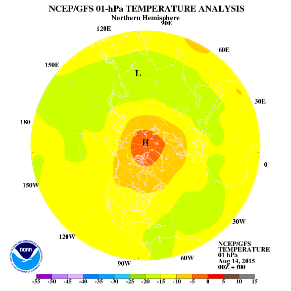
The anomaly in the upper stratosphere.

[mod: I assume by posting a second same link you forgot to provide both NH and SH so I have added NH here and removed your second comment. –Tim]
Was Theodor Landscheidt an astrologer?
Source: http://en.wikipedia.org/wiki/Theodor_Landscheidt
“Johannes Kepler was a German mathematician, astronomer and astrologer.”
http://en.wikipedia.org/wiki/Johannes_Kepler
ren’s mention of stratosphere temperature fits well with the ozone situation
http://macuv.gsfc.nasa.gov/images/FULLDAY_GLOB.PNG (time of above and this image will differ)
The point is that it is southern polar spring with short wave sunlight started to hit the upper atmosphere, ionising gases, whereas northern pole should by now be stabilised.
Ozone is perhaps the main factor associated with this solar cycle that is affecting the AO. The QBO is involved, but it is always involved, the Baldwin paper speculates on ozone changes in the upper stratosphere and lower mesosphere that further assist the planetary waves that travel to the north pole and break up the polar vortex. The paper suggests UV changes via solar changes could affect these ozone levels. The southern hemisphere because of topography does not experience a polar vortex breakup in the same fashion.
Joanna Haig has recently identified ozone changes above and below 45 km and during private discussions with myself she admitted the changes to UV could be a solid option.
The AO positions the jet stream but is loopy function is already in place, I think this is because of atmospheric changes that affect the Rossby waves that govern pressure cell generation. The jet stream is bending because of the pressure patterns, the pressure patterns are the driver of the loopy jet stream. So the AO position is not as important as the pressure pattern changes, that I think are solar related.
Jet stream depends on the temperature in ozonosphere. The changes start at the top of the stratosphere.
I’m sorry, I do not know English and I use a translator. I will try to the best entries.
As for the current solar activity, I recommend:
http://forum.losyziemi.pl/forum/viewthread.php?thread_id=44&pid=1000000#post_1000000
[[mod: Here is a Google tranlation, see Talkshop top menu for translate tools if you need to use Microsoft instead.
http://translate.google.com/translate?hl=en&sl=auto&tl=en&u=http%3A%2F%2Fforum.losyziemi.pl%2Fforum%2Fviewthread.php%3Fthread_id%3D44%26pid%3D1000000%23post_1000000
–Tim]
In my view, the abnormal temperature in the stratosphere is highly influenced by the strength of the solar wind, and perhaps cosmic rays. Cosmic rays were particularly strong in 2009 and 2010.
http://cosmicrays.oulu.fi/
Aside point about Ozone.
Dobson measured Ozone via specific pairs of spectral lines (ratio, one absorbs, other doesn’t) in direct observation of the sun.
He also did the same at night by direct observation of the moon, which is reflected sunlight.
You can read up on some of the history, above is mentioned here
A few comments up here I point at space based Ozone observation and mention the current southern polar missing data.
Should make more sense now. This applies to many measurements from space, only dayside but nightside information is critical, tends to be papered over in a world without change.
Geoff, the Jet stream is more meridional with the negative AO phase:

ren says:
August 4, 2013 at 4:04 pm
“In my view, the abnormal temperature in the stratosphere is highly influenced by the strength of the solar wind”
Check what you can see with the NAO then:
http://snag.gy/nf9SK.jpg (monthly solar wind speed up to 30.06.2013)
http://www.cpc.ncep.noaa.gov/products/precip/CWlink/pna/month_nao_index.shtml
Ren: Please add some text when you post a comment with links. WordPress spam filter catches comments with links. Thanks.
@Ulric,
I think we need to re think the old concepts of the past in relation to the jet stream. Our current conditions have not been the same since the Dalton. The winter of 2011/12 saw a meridional jet stream with a positive AO, the extra low pressure cells being the key. We are in a new paradigm right now, that many in the meteorlogical arena are not seeing.
@Geoff
It was pretty zonal until the cold shot late Jan into Feb:
http://squall.sfsu.edu/scripts/nhemjet_archloop.html
And here’s the daily AO:
011 12 1 3.001
2011 12 2 4.350
2011 12 3 3.948
2011 12 4 3.298
2011 12 5 3.571
2011 12 6 3.729
2011 12 7 2.419
2011 12 8 1.270
2011 12 9 0.991
2011 12 10 1.408
2011 12 11 1.553
2011 12 12 1.973
2011 12 13 1.752
2011 12 14 1.083
2011 12 15 0.596
2011 12 16 0.449
2011 12 17 -0.018
2011 12 18 0.335
2011 12 19 0.836
2011 12 20 0.853
2011 12 21 0.888
2011 12 22 1.378
2011 12 23 2.556
2011 12 24 3.570
2011 12 25 3.824
2011 12 26 3.473
2011 12 27 2.614
2011 12 28 2.607
2011 12 29 2.563
2011 12 30 2.661
2011 12 31 2.865
2012 1 1 1.831
2012 1 2 0.941
2012 1 3 0.959
2012 1 4 1.442
2012 1 5 0.824
2012 1 6 0.189
2012 1 7 0.123
2012 1 8 1.171
2012 1 9 1.739
2012 1 10 1.489
2012 1 11 1.455
2012 1 12 1.161
2012 1 13 0.883
2012 1 14 0.365
2012 1 15 0.471
2012 1 16 0.276
2012 1 17 0.184
2012 1 18 0.732
2012 1 19 0.585
2012 1 20 0.261
2012 1 21 -0.769
2012 1 22 -2.010
2012 1 23 -2.211
2012 1 24 -1.775
2012 1 25 -1.292
2012 1 26 -1.653
2012 1 27 -2.837
2012 1 28 -3.451
2012 1 29 -2.906
2012 1 30 -2.473
2012 1 31 -2.275
2012 2 1 -2.465
2012 2 2 -2.293
2012 2 3 -1.887
2012 2 4 -1.595
2012 2 5 -2.026
2012 2 6 -1.974
2012 2 7 -2.086
2012 2 8 -1.859
2012 2 9 -1.488
2012 2 10 -0.933
2012 2 11 -0.180
2012 2 12 0.040
2012 2 13 0.140
2012 2 14 0.310
2012 2 15 0.697
2012 2 16 0.986
2012 2 17 0.822
2012 2 18 0.397
2012 2 19 0.336
2012 2 20 0.599
2012 2 21 1.528
2012 2 22 2.444
2012 2 23 2.343
2012 2 24 1.651
2012 2 25 0.665
2012 2 26 0.755
2012 2 27 2.178
2012 2 28 1.910
2012 2 29 0.962
I forecast that tiny dip in the middle of Dec 2011 too. The only thing I mucked up on that winter was the very warm second half of Feb, down to Ceres of all things.
A deeply negative AO will always provide the biggest hits as it did in the brief period in early Feb 2012. But there was much evidence of the loopy movement during the very positve stages of the AO. The first 2 weeks of December are a good example which saw much movement over the west coast of the USA and also a very low jetstream positioned over the Himalayas.
This is very different to the positive AO conditions experienced in the 80’s and 90’s.
Forecasts need to be placed early and submitted to one’s own website where they can be measured, before any credence can be gained.
Ulric Lyons
I suggested a plot of cosmic rays from the station in Oulu.
I thought it would be more in line with the solar wind. For example, cosmic rays from 2005 began to increase rapidly and took the highest value on record in Oulu in 2009 and 2010. You can not see it so clearly in the chart of the solar wind.
Cosmic rays are extremely sensitive to solar activity. For example, yesterday magnetic storm brought down immediately, as seen in the graph of Oulu.
Of course, the solar wind speed increased from more than 300 to more than 500 km / s . If we chart since 1964, it is clear what is happening in the solar cycle 24.
“But there was much evidence of the loopy movement during the very positve stages of the AO. The first 2 weeks of December are a good example which saw much movement over the west coast of the USA and also a very low jetstream positioned over the Himalayas.”
You’re having a laugh, that’s tiny! Compare Dec 2011 with Dec 2010:
http://squall.sfsu.edu/scripts/nhemjet_archloop.html
More low pressure cells south of the jet would have to directly cause a more negative AO. Your theory is self-contradictory.
“Forecasts need to be placed early and submitted to one’s own website where they can be measured, before any credence can be gained.”
What makes you think you can lay down the rules? My forecast is public for all to see.
And what of your 2011-12 winter forecast:
“So the prediction is for another massive Northern Hemisphere winter but at this stage it is unclear who will be affected most.”
An abject failure, as it was for Piers so you’re not alone.
Ulric,
We await your forecast for the coming NH winter. Maybe Rog could post it here for you?
I linked in my first comment up-thread.
OK Ulric, lets run with it, a comment on some Linkedln forum:
“Ulric L. • Hi Len As you know, I am forecasting a long intense cold shot starting from around the 7th January 2014. The first signs of any warmer bursts are in the last 10 days of February, which for the UK/Euro will likely result in heavy snow falls, and the Atlantic flow finally breaking through early March. The (north east?) U.S. could see the cold continue further into March.
This is a solar based forecast, produced entirely from heliocentric planetary angular analysis.”
Is that it, or do you have more to offer?
You say its getting cold in early January and should warm up late February, challenging stuff!…. What are your predictions for the AO, the jet stream and ENSO, along with some reasoning which might be helpful.
“You say its getting cold in early January and should warm up late February, challenging stuff!”
[snigger]
Sorry Ulric, couldn’t help it. 🙂
Geoff. I think maybe Ulric means *colder than average for January* and *warmer than average for late February*
Right Ulric?
“Is that it, or do you have more to offer?”
Leave it out Geoff, I do highly reliable and very accurate forecasts for when the solar signal dictates the AO/NAO go negative and we get the cold shots. Jan/Feb 2014 one is a long one.
@Rog
It’s like this: for Jan 2013 I forecast a cold shot from the 8/9th, and sure enough we got got a cold shot from the 8/9th. The next warmer signal I was seeing from the solar signal was from the 18/19th, which did strongly pick up the Atlantic flow, but not enough to break through the high pressure in UK/Euro. The result is a mixing of the air masses and lots of snow, and continuing cold until the westerly flow can finally break the high block. It’s this type of scene I expect for the last week of Feb 2014.
Rog translates my “a long intense cold shot” into *colder than average for January*
Oh thanks for that Rog! /sarc
Ok Ulric, I’m just trying to help keep it all playful.
So is this ‘intense cold shot’ going to be accompanied by a blocking high over Greenland and a strongly negative A.O.?
You can assume more negative AO/NAO conditions and a more southerly/meridional jet through the indicated period, that should have been well obvious. I made comment on ENSO up-thread.
If you like being playful Rog, why not poke fun at Geoff. He issues almost the same forecast each winter, it boils down to one line with never any monthly or weekly detail, and more often it’s not even a forecast but a question lol…
“Yet Another Massive Winter Heading for the Northern Hemisphere?”
“A Massive Winter Heading for the Northern Hemisphere?”
“So the prediction is for another massive Northern Hemisphere winter but at this stage it is unclear who will be affected most.”
Ulric: No-one has the monopoly on forecasting here, so feel free to submit one with as much detail as you like. Weekly sounds great. 🙂
Don’t criticise Geoff for being tentative, unless you’re prepared to stick your neck out further. I appreciate you’ve already done this to some extent, I’m encouraging you to go further.
I’ll criticise him for insinuating that I don’t have much to offer, when he in fact has offered far less.
You know what that is called.
For Jan+Feb 2014 I’m looking at one big long cold shot, I’ve given near daily detail on the start and the breakdown dates. I stick my neck as far as can be done, I give deterministic forecasts for a high proportion of periods because I know how the planetary forcing works. No one else can claim that.
You can see that the situation in the northern stratosphere stabilizes.
However, sunspots quickly lose activity, as well as for long periods of the previous winter, which can bring surprises.


Geoff Sharp says:
August 3, 2013 at 1:08 pm
“Ulric up to his normal form I see.
…winter of 2011/12, which saw a mainly positive AO. The positive AO positioned the jet stream away from the UK for most of the winter.”
“I am not sure what AO data you are using but the official record shows Dec 2010 at an all time neg low for the AO, which corresponded to a jet stream position over the UK, it also shows a positive AO for 2011/12 winter which was the reverse.
http://www.cpc.ncep.noaa.gov/products/precip/CWlink/daily_ao_index/month.ao.gif”
Now why did Geoff bring up 2011/12 winter? I made no reference to it. And why is he presenting 3 month averaged AO data as evidence of positive AO when he was on the edge of his seat watching the daily AO go negative late Jan into Feb 2012?
Geoff says “I just go on the facts”, so I gave him the facts:
[Snip]
[Reply] Please will you and Geoff contact each other by email, and sort out your differences off forum. Thanks. Rog
If you’re going to censor my comments, be kind enough to note that it has been snipped please.
[Reply] OK. Done. Rog
[…] Da Tallbloke Talkshop, Geoff Sharp: Solar based NH Winter forecast […]
[…] https://tallbloke.wordpress.com/2013/08/03/geoff-sharp-solar-based-nh-winter-forecast/#comment-57099 […]